Regional climate change for NW Russia
Various investigations
of the global and local climate changes carried out in different countries
have detected the noticeable increase of the air temperature at the most
of weather stations of the world, and, as a result, of the global air
temperature too (The Global Climate... 1995; Climate of Europe, 1995; Vinnikov,
1986).
At the same time, there are local differences in comparison with the global
warming due to physiographical factors and microclimatic features of some
regions. Hence, the detail investigations of variability of climate elements
at present time and its possible changes in the future are urgent.
 |
The
region of our study (see a map) is located in the north-west part of Russian
Federation (60-70o N and 30-40o E) and includes the territories
of Murmansk district (with administrative area in 144 900 km2), Karelia Republic
(174 200 km2), western part of Arkhangelsk and northern part of Leningrad districts.
The previous research allowed
- developing the data base on principal
meteorological and hydrological characteristics of the territory for the period
beginning from 1880 up to now, reconstruction of missing data for the separate
years and, as a result, constructing continuous monthly- and annual-average
time series;
- analysing the climate
data;
- analysing the dendrochronological
data;
- comparison
of the data obtained by direct measurements with model data obtained
in MPI (ECHAM-4) for the period 1960-1999;
- estimating, on this base, the
possible climate and water balance changes of studied region in the period
2000-2050 for two scenarios of changes CO2, aerosols and greenhouse gases
content at atmosphere of the Earth.
|
Two tables (tab1
and tab2) contain the following arrays
on hydrometeorological information averaged for the territory of Karelia for
the period 1880-1999 (measured) and up to 2050 (received with use of the ECHAM-4
model):
R1 is annual river run-off (mm);
T1 is annual air temperature (°C);
R15 is 15-year moving average river run-off (mm);
R15G is 15-year moving average river run-off, 1999-2050, G-scenario (mm);
R15GA is 15-year moving average river run-off, 1999-2050, GA-scenario
(mm);
PE15 is 15-year moving average potential evaporation (mm);
PE15G is 15-year moving average potential evaporation, 1999-2050, G-scenario
(mm);
PE15GA is 15-year moving average potential evaporation, 1999-2050, GA-scenario
(mm);
E15 is 15-year moving average total evaporation (mm);
E15G is 15-year moving average total evaporation, 1999-2050, G-scenario
(mm);
E15GA is 15-year moving average total evaporation, 1999-2050, GA-scenario
(mm);
T15 is 15-year moving annual air temperature (°C);
T15G is 15-year moving average annual air temperature, 1999-2050, G-scenario
(°C);
T15GA is 15-year moving average annual air temperature, 1999-2050, GA-scenario
(°C);
P15 is 15-year moving average precipitation (mm);
P15G is 15-year moving average precipitation, 1999-2050, G-scenario (mm);
P15GA is 15-year moving average precipitation, 1999-2050, GA-scenario
(mm).
All gaps in R1 and T1 arrays were re-constructed with use of data on river
run-off and air temperature for the territory of Finland, data on total run-off
of rivers Vuoksa, Volkhov, Svir and other analogous territories. Use of this
approach allows receiving continuous arrays of data for the period considered.
Arrays xxxG and xxxGA were calculated with use of data from the model mentioned
above. In order to make them comparable, all water balance parameters are expressed
in mm.
[Abbreviations used: doubling of the greenhouse gases (G-scenario) and greenhouse gases + direct effect of aerosol (GA-scenario)]
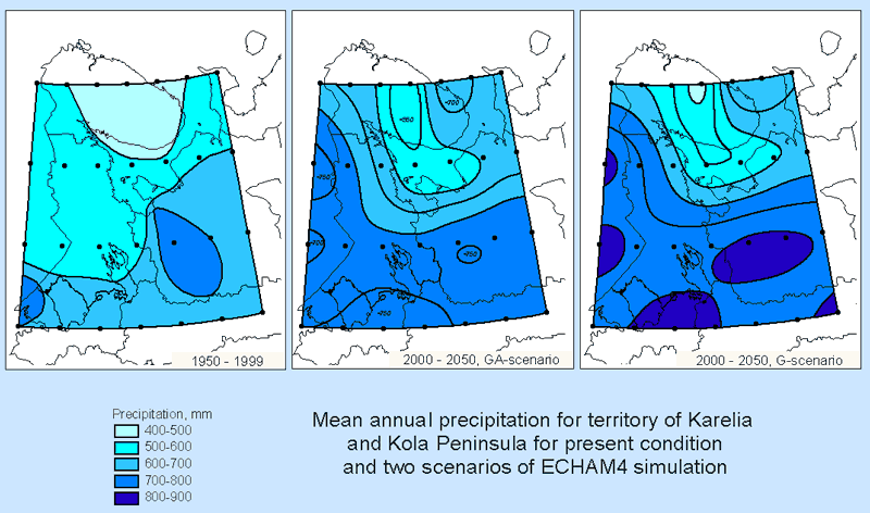
Two following pictures show the results of climate modelling for NW Russia received with use of the
ECHAM-4 model:


The pictures demonstrate that ECHAM-4 model predicts increase of temperature
and precipitation in the region in 2000-2050 for both G (doubling of the greenhouse gases) and
GA (greenhouse gases + direct effect of aerosol) scenarios.
Remember, that other models may have different outcome. Carefully weighted review
of possible climate change can be found in the last assessment report of IPCC,
the Third Assessment Report (TAR), Climate Change 2001, which was completed
in 2001 and can be found at IPCC web site.
References for this section can be found here.


