|
Climate of Karelia
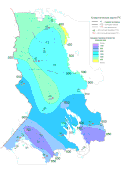
The climate maps published earlier have largely grown out-of-date. Therefore, Northern Water Problems Institute of Karelian Research Centre of Russian Academy of Sciences prepared a new, more representative schematic climate map. The initial materials used to calculate mean multiannual air temperatures (for a year, in January and July) were the series of mean monthly air temperatures from 32 weather stations in Karelia over no less than 30 years. This was usually the period from 1936 to 1990. During World War II observations were carried out only at 5 stations. Also used were the observations started in the 1950's and reduced to the main time series. Data on the stated observation posts were marked on the map and the corresponding isometric lines of the surface air temperature were drawn. The map gives also the absolute maximum and minimum air temperature values from the beginning of the observations to 1990. E.g., instrumental observations at the Petrozavodsk stations began in 1815. Data of observations over precipitation amounts (mm) at 32 stations and 63 posts were used to calculate mean multiannual total precipitation. As in the case with air temperature 1936 was chosen as the year to start. The variability of the main water balance elements (precipitation, river discharge), recurrence of the western type of circulation (Wangenheim) and mean air temperature in the decades in the period from 1880 to 1994 in Karelia were calculated. Moving averaging was used to reduce high-frequency "noise" and more clearly identify slow changes. Analysis of the data on the temperature indicates the presence of a positive trend with the 0.40C air temperature growth in the 115-year period. This value well corresponds to the estimates of the surface temperature changes in the Northern hemisphere, which show the upward trend of 0.50C in 100 years. The mean annual air temperature trend within the century in Karelia at large was not monotonously growing: a very warm decade in the 1930's was followed by the cold period of 1965-1970 with further growth of mean annual air temperatures by the late 1980's. Detailed analysis of seasonal temperatures recorded at the Olonets, Petrozavodsk and Louhi weather stations during instrumental observations showed that the autumn and winter seasons grew colder in the second half of the XX century, but positive trends in the spring and summer temperature series resulted in the overall increase of mean annual air temperatures. Spring and summer in Karelia are about 2-30C colder, and the mean annual air temperature is 1-20C lower. Besides, summer temperatures in Karelia are more stable. A notable positive trend (118 mm in 100 years) was recorded also in the total annual precipitation series which is mainly the consequence of longer periods with the western air transport during the year in Karelia. It should be kept in mind however that the absolute value of annual precipitation increment includes also the method error due to incomplete recording of precipitation in the observation network in the end of the last century and up to the 1930's. Therefore, it can only be stated for sure that total annual precipitation in Karelia has increased during this century. Generally, increase in precipitation and annual air temperature result in higher total evaporation from the territory. Total river discharge in Karelia shows a slight upward trend (13 mm in 100 years). Changes in the water level and water balance elements in the largest European lakes can be considered as integral parameters of the effect of the climate change and anthropogenic factors on the hydrological characteristics of their drainage areas. The results obtained do not allow to definitely state that changes in the lake level and water balance elements depend on man-induced climate changes caused by the "green-house" effect. Present day values of the lake levels were recorded in the past and are the result of natural climate fluctuations rather than its anthropogenic changes. The results indicate that the climate and total water content in Karelian territory are subject to considerable natural fluctuations with the changes caused by anthropogenic factors superimposed on them. |