
Variations of Arctic sea ice extent in the 20th century from dataset based on available Russian observations
To investigate the intrasecular oscillations in ice spreading throughout the 20th century, series of average monthly areas of ice extent were used regardless of ice concentration obtained by different observation instruments and hence having a different degree of reliability. Thus, the duration of these series and their coverage within a year vary from one Arctic Ocean region to another and this fact should be taken into account in the analysis of intrasecular variations. To obtain a generalized picture of sea ice development over as great area of the Arctic Ocean as possible with the maximum observation duration preserved, we have to be restricted to a region of this ocean of 11 347 million km2 comprising 77% of its area. This region occupies the entire central part of the ocean that is ice covered the year round and the marginal Norwegian, Barents, Kara, Laptev and East-Siberian Seas and the western Chukchi Sea. It does not include the eastern Chukchi Sea, Beaufort Sea, straits of the Canadian Arctic Archipelago, Hudson Bay, Baffin Bay and Davis Strait.
Sea ice of the North-European Basin (Norwegian, Greenland, Barents and White Seas) includes the East-Greenland ice belt over its entire length from Fram Strait in the north to Cape Farvel at the extreme south of Greenland and Barents Sea ice. The external boundary of North-European ice adjoins open water and unlike other ocean areas, the shores do not prevent its growth in the horizontal direction. The geographic location of these boundaries from April to August of each year is known from the beginning of the 20th century. The only exception is a 6-year period belonging to the time of the World War II.
These data do not obviously give a complete picture of ice cover development as they cover only a 5-month spring-summer period of the year. In order to fill this gap, a reconstruction of the average annual sea ice area over the first six decades of the 20th century was attempted based on April-August data. Beginning from 1959, there is no need in such a reconstruction, as ice observations in the North-European Basin attain a year-round character.
With this aim based on actual year-round data for 1959-1988, an equation to calculate the average annual ice area in the North-European Basin (Y) based on its average in April-August (X) was derived: Y = 0.89X + 100. The correlation coefficient between X and Y comprised 0.94 ± 0.01. Using this equation, the calculation of missing data for the period 1900-1958 was made (Fig.1).
Fig.1 Annual mean area, covered by the ice in the North-European basin
The main problem of any reconstruction is a question of errors inevitable at the procedures of data series reconstruction. The answer to this question can be obtained by comparing the actual and the calculated values of average annual ice area in this case for the period from 1959 and by calculating the RMS error of reconstruction. This error turned out to be equal to S = ± 52 thousand km2 at the RMS deviation of the initial actual series s = ± 154 thousand km2 respectively with the ratio of S/s =0.34. Thus, the methodological error of reconstruction comprises one third of the RMS deviation of the actual series. This result indicates quite a high reliability of the reconstruction method used.
Consider the intrasecular changes in ice spreading in the Siberian Arctic waters that include the Kara, Laptev, East-Siberian and western Chukchi Seas (with a total area of 2508 million km2). These waters are covered much of the year with solid ice from the Asian continent shores to their external boundaries. Regular data characterizing their state along the entire Northern Sea Route, i.e. from Novaya Zemlya to Bering Strait for the middle of the Arctic summer are presented on figure 2. This is the longest ice data series for this region. Until the late 1930s, its basis was mainly comprised of en-route shipborne observation data and later of airborne ice reconnaissance and satellite data. With time, the period of observations also extended first over the navigation season and then over the entire year.
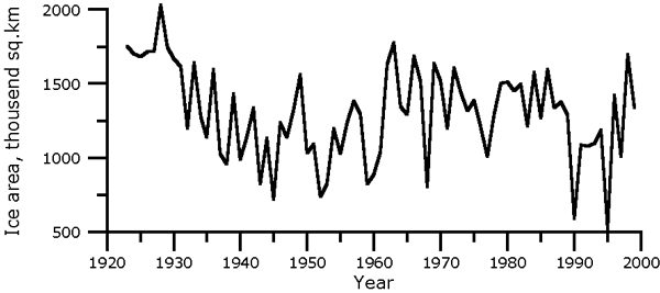
Fig.2 Ice extent in Siberian Arctic basin in the second half of August
It is important to note that the contribution of the Siberian portion of the ice cover turns out to be comparatively small. Ice of the East-Greenland and Barents Sea makes the greatest contribution. In the mean annual expression, its fraction comprises 80% of this dispersion. This result is important as it allows a judgement of the most important sea ice area changes over much of the Arctic Ocean (77% of its area) based only on the data for the North-European basin. The fact is that sea ice beyond the northern boundary of the marginal seas is preserved the year-round and does not influence the variability of its area. An assessment of the closeness of relationship between the average annual ice area in this part of the ocean (fig.3) and the average ice area for April-August in the North-European Basin obtained from actual data for 1960-1994 confirms the validity of this conclusion.

Fig.3. Annual mean ice area over much of the Arctic Ocean (77% of its area)
The correlation relationship between them expressed by the coefficient of 0.93± 0.02 allows us to sufficiently reliably reconstruct the changes of the mean annual sea ice area in the Arctic Ocean from data on the North-European Basin.
Two first decades of the 20th century in the Arctic were distinguished by the conditions that were non-existent during all subsequent years (table 1). This was expressed in lower water and air temperatures and a greater level of sea ice extent. The difference in its average values for 1900-1920 and 1921-1939 comprised 308 in May, 377 in June, 441 in July, 273 in August and 309 thousand km2 during a year. It is important that the transfer from a higher level of ice extent at the beginning of the century to the next lower level occurred suddenly and was very sharp. It was accompanied with a similar sudden increase of surface air temperature in the Arctic that signified a change of one climatic epoch to another. From this time, the character of the ice cover behavior that entered a regressive phase of its development has also changed. Until 1918, the processes of its expansion with a mean annual rate of +159 thousand km2/decade predominated.
Table 1
Mean annual ice area in the Arctic Ocean (77 % of the ocean area in its formal
boundaries), thousand km2
|
Years |
0 |
1 |
2 |
3 |
4 |
5 |
6 |
7 |
8 |
9 |
|
190. |
8595 |
8686 |
8799 |
8705 |
8372 |
8645 |
8732 |
8618 |
8542 |
8726 |
|
191. |
8662 |
8728 |
8899 |
8830 |
8779 |
8684 |
8865 |
8952 |
8988 |
8609 |
|
192. |
8536 |
8519 |
8377 |
8527 |
8450 |
8310 |
8557 |
8647 |
8619 |
8724 |
|
193. |
8380 |
8369 |
8388 |
8329 |
8507 |
8395 |
8285 |
8240 |
8256 |
8128 |
|
194. |
8415 |
8559 |
8495 |
8301 |
8300 |
8254 |
8274 |
8140 |
8325 |
8363 |
|
195. |
8221 |
8244 |
8383 |
8166 |
8112 |
7958 |
8128 |
8032 |
8211* |
8153 |
|
196. |
7996 |
8094 |
8373 |
8582 |
8337 |
8374 |
8573 |
8530 |
8593 |
8745 |
|
197. |
8374 |
8323 |
8336 |
8230 |
8164 |
8237 |
8184 |
8235 |
8363 |
8428 |
|
198. |
8526 |
8419 |
8465 |
8227 |
8053 |
8158 |
8291 |
8394 |
8432 |
8364 |
|
199. |
7925 |
8029 |
8066 |
8100 |
8100 |
7926 |
8395 |
|
|
|
Note: * - from here and further, data are actual.
From 1918, the ice area in the North-European basin and in the other regions of the Arctic Ocean began to decrease (Viese, 1932, 1937, 1940, 1941, 1944). The ice area in August in the Barents, Kara, Laptev, East-Siberian and Chukchi Seas taken together has decreased from 1924 to 1940 by about 1 million km2. The East-Greenland ice belt has decreased in size from 1898-1920 to 1921 -1938 by 157 thousand km2 in April, 186 in July and 95 thousand km2 in August. As a result, the average ice boundary was displaced westward up to 75 nautical miles in places and near the shores of Spain, ice ceased to appear. The ice cover of the Barents Sea in May-June that comprised 61% in 1896-1919 decreased to 47% in 1920-1940 with the ice edge in this sea retreating northward by about 120 km. In the other Arctic Seas the ice area retreat also occurred in the summertime being even greater almost everywhere than in the Barents Sea.
The observation gap during the World War II does not allow us to accurately determine the time when a multiyear minimum in ice spreading was achieved and the new third stage in its development began. The features of this new climatic stage within the Russian Arctic were most pronounced in the Kara Sea. The average annual temperature at the stations of this sea decreased by 2-4o compared to the moment of culmination of warming at the border of the 1930s and 1940s. This decrease beyond the Kara Sea lost its intensity quite quickly especially eastwards being even replaced by small warming at some stations of Chukotka. A significant ice concentration increase from 1946-1995 towards the subsequent two decades occurred in the Kara Sea. This increase also extended to a lesser extent to the Laptev Sea. On the contrary, in the East-Siberian and the Chukchi Seas, the ice concentration decreased from the beginning to the end of this intrasecular stage.
The end of the third and the beginning of the fourth current stage in the development of the ice cover in the Arctic falls on the very end of the 1960s (to be more exact on 1968). It was followed by weak at first and then from the early 1990s quite intense ice area decrease that influenced although to a different extent the entire Arctic Ocean. A sufficiently weak sea ice area decrease throughout the 1970s-1980s has practically become more intense in the entire marginal area of the Arctic Ocean with the beginning of the new decade. Thus, the East Greenland ice belt in August reduced from 539 to 278 thousand km2 from 1989 to 1990 and the Barents Sea ice from 222 to 97 thousand km2. The ice area decreased from 456 to 79 in the East-Siberian Sea and from 393 to 109 thousand km2 in the Laptev Sea. The exception is the Kara Sea where no similar changes were noted. The process of ice situation improvement was not restricted only to the marginal seas extending to the central Arctic and the other ice-infested areas of the Northern Hemisphere. An assessment of linear trends of sea ice area in the Northern Hemisphere (Vinnikov et al., 1999) is further evidence of the direction of changes. According to (Johannessen et al., 1999), the process of the decrease of ice cover dimensions was accompanied with the multiyear ice area decrease in the Arctic Basin. This area decreased by 610 thousand km2 from the late 1970s to the end of the century. A comparison of the sea ice draft data in the deep-sea Arctic Ocean at the end of the period of melting indicates a strong ice thickness decrease (by 1.3 m) from 1958-1976 by 1993-1997 (Rothrock et al., 1999).
We refer the boundary between the second and the third stages to 1939, which is not in agreement with ice cover extent variations in Fig. 4. In doing this, we were guided first by the fact that the first intra-secular maximum of surface air temperature in the polar area was in 1939 and, second, by the doubts in the high quality of ice state data in the 1940s and in the first half of the 1950s. Each of these stages is characterized by the following linear trend parameters: 1900-1918 b=+169 thousand km2/decade, 1918-1939 b= -200 thousand km2/decade, 1939-1968 b= +25 thousand km2/decade and 1968-1996 b= -121 thousand km2/decade.
Table 2 contains evidence on the contribution of the individual seas to the variability of the ice extent of the Arctic Ocean. As can be seen, the contribution of the Siberian portion to the total dispersion of changes in the total arctic ice area turns out to be comparatively small, while the contribution of the East-Greenland and Barents Sea ice is overwhelming. In the mean annual expression, the fraction of the latter comprises 80 % of dispersion making it possible to judge about the sea ice area change in the Arctic Ocean (to be more exact over 77 % of its area), based on the North-European Basin data. An assessment of the closeness of relation between the mean annual ice areas in this part of the ocean and in the North-European Basin confirms the relevance of this conclusion. The correlation relation between them in the

Fig. 4. Mean annual sea ice area in the Arctic Ocean in deviations from an average
Table 2
Contribution of the individual seas to the dispersion of ice area changes
in the Arctic Ocean in different months of the year, %
|
X |
XI |
XII |
I |
II |
III |
IV |
V |
VI |
VII |
VIII |
IX |
|
|
EG |
24 |
43 |
55 |
56 |
52 |
51 |
42 |
35 |
29 |
26 |
11 |
11 |
|
B |
43 |
57 |
45 |
44 |
48 |
49 |
58 |
65 |
58 |
39 |
15 |
12 |
|
K |
24 |
0 |
0 |
0 |
0 |
0 |
0 |
0 |
9 |
18 |
22 |
17 |
|
L |
2 |
0 |
0 |
0 |
0 |
0 |
0 |
0 |
3 |
10 |
24 |
21 |
|
ESC |
4 |
0 |
0 |
0 |
0 |
0 |
0 |
0 |
4 |
11 |
26 |
34 |
|
WC |
2 |
0 |
0 |
0 |
0 |
0 |
0 |
0 |
-3 |
-4 |
2 |
5 |
Note: EG - East Greenland waters; B - Barents Sea;
K - Kara Sea; L - Laptev Sea; ES -East-Siberian Sea;
WC - western Chukchi Sea.
1958-1996 time interval is expressed by a coefficient of 0.95. The intra-secular stages in the development of sea ice in the North-European Basin as can be seen in Fig. 5, fully correspond to the stages in Fig. 4. This is also confirmed by surface air temperature variations in the latitudinal belt of 85-65° N.

Fig. 5. Mean annual sea ice area in the North-European Basin in deviations from an average
The contribution of the individual seas to the total dispersion of the mean annual ice area corresponds to: EG - 36%, B - 44%, - 8%, L - 5%, ES - 7 % and WC - 0%.
We shall discuss now each of these stages in greater detail using for this different indicators of the intra-secular dynamics of the ice regime.
First intra-secular stage (1900 -1918). The first two decades of the 20th century in the Arctic were distinguished by the conditions that were absent in all subsequent years. This was expressed in lower water and air temperatures and a higher ice cover extent. As can be clearly seen from Fig. 4, these differences in these levels before and after 1918 are quite pronounced. The difference in mean sea ice areas in the Arctic Ocean between the 20-year periods 1900-1919 and 1920-1939 comprised 262 in April, 343 in May, 239 in June, 397 in July, 433 in August and 294 thousand km2 during a year. It is important that the transition from a high level of ice extent at the beginning of the century to the next lower level occurred suddenly in a jump. It was accompanied with a similar sudden increase of surface air temperature in the Arctic signifying one climatic epoch being replaced by another. The mean annual surface temperature in the latitudinal belt of 85-650 N from the first 20-year period to the second one has increased by 1C. The character of behavior of the ice cover that entered the regressive phase of its development has also changed. Table 3 presents the linear trend parameters for each intra-secular stage of ice cover development in the 20th century.
Table 3
Linear trend parameters b of sea ice area in
the Arctic Ocean by the stages of its development (thousand km2/decade)
|
Period |
1900-1918 |
1918-1938 |
1946-1968 |
1968-1996 |
|
October |
|
|
|
-77 |
|
November |
|
|
|
-34 |
|
December |
|
|
|
-76 |
|
January |
|
|
|
-104 |
|
February |
|
|
|
-118 |
|
March |
|
|
|
-150 |
|
April |
+121 |
-134 |
+6 |
-173 |
|
May |
+187 |
-164 |
+44 |
-182 |
|
June |
+182 |
-116 |
+124 |
-143 |
|
July |
+195 |
-342 |
+198 |
-154 |
|
August |
+239 |
-431 |
+188 |
-141 |
|
September |
|
|
|
-107 |
|
Mean annual |
+169 |
-200 |
+122 |
-122 |
Data on the ice boundaries of the East-Greenland and Barents Seas in April-August and changes in their location contained in Tables 4 and 5 shed some additional light on the ice conditions during the first two decades of the 20th century.
Table 4
Location of the external boundary of East-Greenland ice in April-August 1898-1920
and its change by 1921-1938
|
Latitude |
Longitude in 1898-1920 |
Change in the boundary location* |
||||||||
|
IV |
V |
VI |
VII |
VIII |
IV |
V |
VI |
VII |
VIII |
|
|
60° |
40°30 |
41°30 |
41°30 |
41°20 |
43°00 |
-1°30 |
-0°30 |
-0°30 |
-0°55 |
-1°00 |
|
61 |
40 00 |
40 00 |
40 45 |
41 00 |
43 00 |
-1 00 |
-0 30 |
-1 00 |
0 00 |
0 00 |
|
62 |
39 10 |
39 30 |
40 20 |
40 40 |
42 30 |
-0 55 |
0 00 |
-0 40 |
0 00 |
0 00 |
|
63 |
39 00 |
38 50 |
39 40 |
40 00 |
41 30 |
-0 45 |
-0 50 |
-0 20 |
0 00 |
0 00 |
|
64 |
38 00 |
38 00 |
38 30 |
39 00 |
41 00 |
-0 30 |
1 10 |
0 00 |
0 00 |
0 00 |
|
65 |
35 00 |
35 00 |
36 00 |
36 30 |
40 00 |
-1 00 |
-0 30 |
-1 00 |
0 00 |
0 00 |
|
66 |
28 00 |
27 00 |
29 30 |
30 00 |
34 00 |
-5 30 |
-5 00 |
-3 30 |
-4 30 |
-1 00 |
|
67 |
20 00 |
24 00 |
23 00 |
26 00 |
30 00 |
-8 00 |
-7 30 |
-4 00 |
-4 00 |
-0 30 |
|
68 |
14 30 |
17 00 |
19 00 |
20 00 |
25 00 |
-6 00 |
-4 00 |
-1 30 |
-3 00 |
0 00 |
|
69 |
12 00 |
13 50 |
16 30 |
18 00 |
22 00 |
-4 00 |
-2 40 |
-1 00 |
-2 00 |
1 00 |
|
70 |
10 00 |
11 00 |
13 30 |
16 00 |
20 00 |
-3 00 |
-3 00 |
-1 30 |
-2 00 |
1 00 |
|
71 |
8 00 |
8 20 |
10 30 |
14 00 |
18 00 |
-3 00 |
-3 10 |
-2 30 |
-2 30 |
0 00 |
|
72 |
5 00 |
7 00 |
8 30 |
12 30 |
16 00 |
-4 30 |
-2 30 |
-3 00 |
-2 30 |
-2 00 |
|
73 |
3 00 |
5 00 |
6 00 |
1 00 |
14 00 |
-5 00 |
-3 00 |
-3 30 |
-4 00 |
-2 00 |
|
74 |
1 30 |
3 00 |
4 00 |
7 00 |
12 00 |
-4 30 |
-3 50 |
-3 30 |
-5 30 |
-2 00 |
|
75 |
0 30 * |
1 30 |
2 30 |
4 00 |
9 00 |
-4 30 |
-3 30 |
-3 30 |
-6 00 |
-3 00 |
|
76 |
2 00 * |
1 00 |
1 00 * |
2 00 |
8 00 |
-3 30 |
-3 00 |
-3 00 |
-6 00 |
-2 00 |
|
77 |
5 00 * |
3 00 * |
1 00 * |
1 00 * |
6 00 |
-5 00 |
-3 30 |
-3 00 |
-6 00 |
-2 00 |
|
78 |
7 00 * |
5 00 * |
2 30 * |
3 00 * |
3 00 |
-4 30 |
-3 30 |
-2 30 |
-6 00 |
-2 00 |
|
79 |
10 00 |
7 00 * |
6 00 * |
6 00 * |
0 00 |
-5 00 |
-2 00 |
-4 00 |
-5 00 |
-3 00 |
|
80 |
Ice |
11 00 |
10 00 |
11 00 |
6 00 |
|
-1 00 |
-3 00 |
-7 00 |
-4 00 |
Note: The change in the ice boundary location by 1921-1938 is given in degrees and minutes of longitude;
Sign "- " denotes the westward boundary displacement;
*- denotes eastern longitude, in all other cases, the
longitude is western.
Table 5
Northern boundary of sea ice in the Barents Sea in 1898 - 1920 and change
of its boundary by 1921 -1938
|
Longitude |
IV |
V |
VI |
VII |
VIII |
IV |
V |
VI |
VII |
VIII |
|
15° E |
75°55 |
76°0 |
77°00 |
|
|
|
|
|
|
|
|
20 |
73 30 |
73 50 |
74 40 |
76°30 |
76°50 |
-2°25 |
-1°00 |
-1°15 |
|
|
|
25 |
73 25 |
73 55 |
74 50 |
76 20 |
76 50 |
-2 30 |
-2 05 |
-1 55 |
-1°15 |
-2°10 |
|
30 |
73 10 |
73 50 |
74 20 |
76 20 |
77 20 |
-2 40 |
-2 10 |
-2 40 |
-1 05 |
-1 00 |
|
35 |
72 15 |
73 30 |
74 00 |
75 50 |
77 00 |
- 3 15 |
-2 20 |
-2 50 |
-1 00 |
-1 40 |
|
40 |
71 00 |
72 05 |
74 00 |
75 50 |
77 20 |
-3 50 |
-3 00 |
-1 45 |
-2 10 |
-2 00 |
|
45 |
|
|
74 15 |
76 00 |
77 15 |
|
|
-0 40 |
-2 15 |
-2 25 |
|
50 |
|
|
|
76 00 |
77 50 |
|
|
|
-2 20 |
-1 50 |
|
55 |
|
|
|
76 15 |
77 45 |
|
|
|
-2 05 |
-2 05 |
|
60 |
|
|
|
76 25 |
77 20 |
|
|
|
-1 35 |
-2 00 |
Note: * - change of the ice boundary location is given in degrees and minutes of longitude;
sign " - " denoted the northward ice boundary displacement.
Second intra-secular stage (1918-1939). From 1918, a decrease of the sea ice area began in the North-European Basin and in the other regions of the Arctic Ocean, whose intensity in the time interval 1918 - 1938 is reflected in data of Table 3. The upper bound of this interval is of a slightly conventional character due to the absence of direct data. As noted above, the first climatic air temperature maximum in the 20th century occurred at the very end of the 1930s. In view of the relationship between the polar atmosphere temperature and sea ice development, this maximum can serve as an indirect indication of the end of the second stage of ice cover development.
V.Yu.Viese presented first evidence about the sea ice area decrease after 1918 in 1926. With time, it was supplemented and made more detailed both in the studies of Viese (Viese, 1932, 1937, 1940, 1941 and 1944) and of other scientists (Zubov, 1938, 1944, 1948; Karelin, 1941). The most important of the results obtained are very briefly described below.
The tendency towards the ice cover extent decrease in most areas of the sub-Atlantic Arctic was outlined at the very end of the second decade of the 20th century. However, it was most pronounced in the 1930s. The ice area in August in the Barents, Kara, Laptev, East-Siberian and Chukchi Seas together has decreased from 1924 to1940 approximately by 1 million km2. The size of the East-Greenland ice belt has decreased from 1898-1920 to 1921-1938 by 157 in April, 186 in July and 95 thousand km2 in August. As a result, the average ice boundary moved westward up to 75 nautical miles in places, while near the shores of Iceland, ice that prevented normal shipping and fishery in waters of this island at the beginning of the century, does not anymore appear.
The ice cover extent of the Barents Sea in May-June that comprised 61 % in 1896-1919, decreased to 47 % by 1920-1940, whereas the ice edge retreated northward by about 120 km. In the other Arctic Seas, the ice area in the summertime also decreased, and according to Viese even on a greater scale almost everywhere compared to the Barents Sea. For example, in the southwestern Kara Sea beginning from 1929, ice in September was not encountered at all although in 1869-1928, the probability of observing it here comprised 30 %. The dates of the freeze up and ice breakup in the coastal sea areas have sharply decreased at this. Thus, while until 1920, the final freeze up of Yugorsky Shar Strait occurred around November 24, on average, in 1920-1937, this freeze up occurred later, on January 25.
The decrease of the ice area was accompanied with the ice thickness decrease. Unfortunately, it is impossible to reliably assess this decrease due to the absence of accurate data. An estimate given in literature for the central Arctic cannot be considered correct. It was obtained by comparing the maximum ice thickness measured during the drift of the "Fram" in 1893-1896 (more than 3 m) and "Sedov" in 1937-1940 (2.2 m.). Not doubting the fact itself of ice thinning in the process of climate warming, one should not however, attribute the difference in thickness entirely to climate changes. This difference could occur due to the fact that the "Sedov" drifted surrounded by younger ice. Suffice it to remind that the "Sedov" began to drift in the Laptev Sea at latitude 75° 21' N, 132° 15' E, whereas the "Fram" - at a point of 78° 50' N, 133° 30' E.
A comparative analysis of the drift of the "Fram" and "Sedov" also served as a basis to make a conclusion about the increased drift velocity in the Arctic Basin during the epoch of climate warming. "The drift of "Sedov", wrote Viese (Viese, 1940), started much more to the south than the "Fram" drift while it occurred much more northward and ended much more southward. The "Fram" drift lasted for 1055 days, and the "Sedov" drift - only for 812 days". In addition, the drifts of the "Sedov", "North Pole" stations and numerous buoys in the 1930s in the Polar basin were noticeably more rapid compared to the drift of the "Zhanetta" and "Fram" in the last quarter of the 19th century and of "Sv.Anna" at the beginning of the 20th century.
The improvement of ice conditions in the 1920-1930s created favorable conditions for shipping. Table 6 presents the dates of the start, end and duration of navigation to Spitsbergen according to (Hesselberg, 1940) that confirm the development of events towards the improved conditions of polar shipping to the shores of this archipelago. The improvement has also occurred at the extreme east of the North-European Basin in the Novaya Zemlya area. As early as the beginning of the 20th century, the navigation situation at the approaches to the straits of this archipelago (Yugorsky Shar, Kara Gate and Matochkin Shar), likewise near the northern tip of Novaya Zemlya - Cape Zhelaniya frequently excluded a passage to the Kara Sea due to ice conditions. In summer of 1901, the icebreaker "Yermak" was not able not only to approach this cape, but also to come up without hindrance to the northern island of this archipelago from the side of the Barents Sea. Moreover, this powerful icebreaker was beset in ice for a whole month. In 1938, the same icebreaker "Yermak" penetrated the Arctic Basin in the sector of the New Siberian Islands to 83°05' N, holding thus a world record of the northern latitude for a freely navigating vessel.
Table 6
Dates of the start, end and duration of navigation to Spitsbergen, according
to [Hesselberg, 1940]
|
Year |
Day, month |
Duration, days |
Year |
Day, month |
Duration, days |
||
|
Start |
End |
Start |
End |
||||
|
1907 |
19.06 |
1.10 |
106 |
1924 |
22.04 |
15.10 |
176 |
|
1908 |
13.06 |
1.10 |
111 |
1925 |
21.05 |
27.10 |
159* |
|
1909 |
30.06 |
1.10 |
94 |
1926 |
24.05 |
17.11 |
177 |
|
1910 |
19.06 |
1.10 |
105 |
1927 |
13.06 |
28.10 |
137 |
|
1911 |
29.06 |
5.10 |
99 |
1928 |
2.06 |
20.10 |
141 |
|
1912 |
1.07 |
6.10 |
98 |
1929 |
8.07 28.08 |
13.08 9.10 |
80 |
|
1913 |
1.07 |
6.10 |
93 |
1930 |
20.05 |
21.10 |
155 |
|
1914 |
1.07 |
7.10 |
99 |
1931 |
23.05 |
18.10 |
149 |
|
1915 |
13.08 |
1.10 |
50 |
1932 |
18.05 |
25.10 |
161 |
|
1916 |
1.07 |
13.10 |
105 |
1933 |
4.05 |
29.10 |
179 |
|
1917 |
21.07 |
2.10 |
74 |
1934 |
2.05 |
31.10 |
183 |
|
1918 |
1.06 |
1.10 |
123 |
1935 |
16.05 |
1.11 |
170* |
|
1919 |
10.06 |
1.10 |
114 |
1936 |
17.05 |
29.10 |
166 |
|
1920 |
24.05 |
11.10 |
141 |
1937 |
3.05 |
6.11 |
188* |
|
1921 |
1.05 |
11.10 |
164 |
1938 |
1.05 |
2.11 |
186 |
|
1922 |
27.05 |
7.10 |
134 |
1939 |
29.04 |
17.11 |
203 |
|
1923 |
9.05 |
9.10 |
154 |
|
|
|
|
N.N. Zubov (Zubov, 1938) pointed out that in 1930, there was not a single occasion when it was impossible to round Novaya Zemlya from the north onboard a ship unsuitable for ice navigation. In summer of 1932 for the first time in the history of shipping, a small expedition ship "Nikolay Knipovich" rounded the Franz-Josef Land from the north whereas the icebreaking vessel "Sibiryakov" - Severnaya Zemlya. In general, the 1930s in the Arctic turned out to be extremely favorable for transit along the Northern Sea Route, which at that time has become a normally operating transport waterway. In summer of 1935, 1937, 1939, 1940, 1941, 1943 and 1945, one could sail without hindrance along the entire coast of Siberia from Novaya Zemlya to Bering Strait.
Third intra-secular stage (1939 - 1968). An assessment of the linear trend parameters at this stage of the Arctic ice development has become possible only from 1946 due to a gap in the observations (Table 3). By this time, a system of ice observations in the Russian Arctic has been already formed with observations themselves attaining a regular character. Due to this, there was an opportunity to investigate their temporal variations, which was used in (Zakharov, 1976). It was shown that the new intra-secular stage of Arctic ice development was manifested in the decreased surface air temperature, earlier ice formation and landfast ice establishment in autumn, its later breakup in spring at the majority of Arctic coastal points and in the open sea, increased ice thickness and slower drift, decreased ice exchange between the marginal seas and the Arctic Basin and in the southward displacement of the old ice boundary including multiyear ice.
Within the Russian Arctic, the features of this new climatic stage were most pronounced in the Kara Sea. The mean annual temperature at he stations of this sea decreased by 2-4o compared to the moment of warming culmination at the boundary of the 1930s and 1940s. This decrease beyond the Kara Sea limits attenuates quite rapidly, especially eastward being even replaced at some stations on Chukotka by an insignificant warming.
Cooling resulted in some important changes in the state of the ice cover in the Arctic Ocean and its seas. The dates of the onset of stable ice formation, for example, at Cape Cheluskin in 1959-1970 were by 25-30 days earlier than in 1941-1945. On Uyedineniya Island, this change comprised 25 days and on Preobrazheniya Island, it was 20 days. A detailed picture of changes in the ice formation in Siberian Arctic waters is presented in Fig. 6. The earlier onset of ice formation and the decreased air temperatures in autumn and winter have influenced the ice thickness (Table 7). The average ice thickness in the vicinity of polar stations in the Kara Sea increased by about 30 cm in the late 1960s compared to the moment of warming culmination. In the Laptev Sea, this increase was only 7 cm while in the East-Siberian Sea, the ice thickness has not practically changed. Thus, even in the area of the largest cooling, which is the Kara Sea, the ice thickness increase was comparatively small.

Fig. 6. Change in average dates of the onset of ice formation near the coast of Siberia from 1946 -1955 to 1956 - 1965 , days (negative values on the map denote earlier ice formation)
Table 7
Ice thickness change in the vicinity of polar stations at the coast and on
the islands of the Arctic Seas during the third intra-secular stage, cm
|
Sea, station |
Dh1
|
Dh2
|
Dh3
|
Dh4
|
Dh5
|
|
Kara Sea, Zhelaniya |
20 |
5 |
26 |
63 |
57 |
|
Yugorsky Shar |
17 |
7 |
23 |
29 |
22 |
|
Bely Island |
12 |
10 |
30 |
4 |
17 |
|
Marre-Salya |
9 |
10 |
9 |
16 |
21 |
|
Dikson Island |
5 |
16 |
26 |
30 |
24 |
|
Cheluskin |
15 |
23 |
27 |
27 |
34 |
|
Andrey Island |
18 |
6 |
2 |
18 |
24 |
|
Russky Island |
15 |
5 |
22 |
7 |
21 |
|
Uyedineniya Island |
6 |
7 |
27 |
28 |
41 |
|
Laptev Sea, Preobrazheniya Island |
-24 |
1 |
10 |
3 |
-7 |
|
Tiksi |
-8 |
1 |
-8 |
-2 |
-2 |
|
Kigilyakh |
12 |
17 |
22 |
-6 |
1 |
|
Sannikov |
6 |
10 |
10 |
-10 |
4 |
|
Kotelny Island |
4 |
6 |
8 |
2 |
-8 |
|
Shalaurov |
1 |
21 |
23 |
1 |
-6 |
|
East-Siberian Sea, Chetyrekhstolbovoy Island |
-4 |
5 |
-15 |
-2 |
-1 |
|
Billings |
-5 |
-5 |
-6 |
-10 |
-12 |
|
Vrangel Island |
12 |
12 |
-2 |
10 |
4 |
|
Chukchi Sea, Vankarem |
8 |
14 |
-12 |
14 |
13 |
|
Bering Sea, Provideniya |
-12 |
-19 |
-14 |
-11 |
-27 |
Note: D h1 , Dh2, Dh3, Dh4, Dh5 - deviation of the average ice thickness during the 5-year periods 1946-1950, 1951-1955, 1956-1960, 1961-1965 and 1966-1970 from the average in 1941-1945. The sign " - " means the ice thickness decrease.
The attenuated intensity of atmospheric circulation in the central Arctic resulted in the slower ice drift in the Arctic Basin. In the 1950s and 1960s, this drift occurred with the velocities that were typical of the period of cooling at the beginning of the century, i.e. of the first intra-secular stage. The average drift speed by the general direction in 1955-1970 was 1.7 km/day. Simultaneously, there was deterioration of ice conditions in the Greenland Sea and in Icelandic waters. Thus, in the 1940s, ice in waters of Iceland appeared in March in 5 cases, in the 1950s - in 7 and during the subsequent 12 years - annually.
The increased ice cover extent in most marginal seas is a phenomenon typical of the third intra-secular development stage. This is indicated in data of Tables 8 and 9 and in Fig. 7. This increase began in the Kara and Laptev Seas (early 1940s), then in the Barents Sea (mid-1950s) and finally in the Greenland and Beaufort Seas and in Davis Strait (mid-1960s). The exception is the Chukchi Sea and the eastern East-Siberian Sea where the ice quantity decreased. A fuller understanding of the spatial non-uniformity features in the changes of ice conditions is given in Fig. 8. As can be seen, there was a noticeable ice concentration increase on the western segment of the Northern Sea Route, especially in the Kara Sea from 1946-1955 to the subsequent two decades. This increase, however, less intense also spread to the Laptev Sea. In the East-Siberian and Chukchi Seas, the ice conditions, on the contrary, improved leading to a decreased ice concentration from the beginning to the end of this intra-secular stage. This "mirror" reflection in the ice cover extent variations between the western and eastern segments of the Northern Sea Route has been known as an ice opposition from the time of V.Yu. Viese.
Table 8
Mean annual ice area in the North-European Basin, thousand km2
|
Years |
0 |
1 |
2 |
3 |
4 |
5 |
6 |
7 |
8 |
9 |
Average |
|
190. |
1430 |
1510 |
1610 |
1528 |
1234 |
1474 |
1551 |
1450 |
1383 |
1545 |
1472 |
|
191. |
1489 |
1547 |
1698 |
1637 |
1592 |
1508 |
1668 |
1744 |
1775 |
1442 |
1610 |
|
192. |
1377 |
1363 |
1238 |
1370 |
1216 |
1114 |
1345 |
1447 |
1351 |
1511 |
1333 |
|
193. |
1157 |
1169 |
1337 |
1115 |
1395 |
1318 |
1126 |
1181 |
1235 |
1064 |
1210 |
|
194. |
1363* |
1487* |
1366* |
1297* |
1183* |
1300* |
1127 |
1068 |
1211 |
1186 |
1259 |
|
195. |
1142 |
1194 |
1339 |
1159 |
1031 |
882 |
968 |
890 |
1028 |
1107 |
1074 |
|
196. |
937 |
1037 |
1163 |
1350 |
1183 |
1266 |
1357 |
1358 |
1566 |
1527 |
1274 |
|
197. |
1181 |
1229 |
1149 |
1118 |
1020 |
1112 |
1087 |
1162 |
1228 |
1262 |
1155 |
|
198. |
1351 |
1238 |
1311 |
1071 |
877 |
993 |
1101 |
1222 |
1274 |
1248 |
1169 |
|
199. |
963 |
959 |
957 |
1041 |
1037 |
974 |
1192 |
|
|
|
|
Note: * - data are reconstructed by the mean annual surface air temperature.
In addition to the increased quantity of ice to the north of the coast of Siberia, there was a change in its age composition. Fig. 9 shows, in particular, the change in the content of multiyear ice that influenced the conditions of shipping.
Fourth intra-secular stage (1968-1999). The end of the third and the beginning of the fourth concluding stage in the ice cover development in the Arctic fell on the very end of the 1960s (to be completely exact, on 1968). It was first followed by a weak and then from the early 1990s, quite an intense decrease in the ice area influencing although to a different extent, the entire Arctic Ocean. The upper bound of the stage cannot be exactly defined to-date due to unclear future development of the ice cover. That is why, it was conventionally referred to the very end of the centennial.

Fig.7. Deviation of ice extent in the Arctic Seas (A) and of air temperature at polar stations (B) in 1946-1970 from their levels in 1941-1945

Fig.8. Ice concentration change along the Siberian coast from the 1946-1955 decade to 1966-1974, tenths

Fig. 9. Change of concentration of old (second -year and multiyear) ice from the 1946-1955 decade to 1956-1965, tenths (positive values denote the increase of concentration towards 1956-1965)
Table 9
Mean annual ice area in Siberian Arctic waters, thousand km2
|
0 |
1 |
2 |
3 |
4 |
5 |
6 |
7 |
8 |
9 |
|
192. |
|
|
|
|
2298 |
2260 |
2276 |
2264 |
2332 |
2277 |
|
193. |
2277 |
2264 |
2115 |
2277 |
2175 |
2141 |
2223 |
2123 |
2085 |
2128 |
|
194. |
2117 |
2136 |
2194 |
2068 |
2181 |
2018 |
2210 |
2137 |
2178 |
2241 |
|
195. |
2143 |
2114 |
2108 |
2069 |
2145 |
2139 |
2224 |
2206 |
2247 |
2110 |
|
196. |
2123 |
2121 |
2274 |
2295 |
2218 |
2171 |
2280 |
2236 |
2091 |
2282 |
|
197. |
2256 |
2158 |
2252 |
2177 |
2208 |
2189 |
2161 |
2138 |
2198 |
2229 |
|
198. |
2240 |
2245 |
2218 |
2220 |
2240 |
2229 |
2253 |
2236 |
2222 |
2180 |
|
199. |
2026 |
2134 |
2173 |
2123 |
2181 |
2016 |
2287 |
2091 |
2263 |
2146 |
Data of Table 3 indicate that the linear trends at this stage are characterized the year-round by the decreased level of ice cover extent by the end of the century. However, the intensity of this decrease experiences strong seasonal changes with a minimum in November (-34 thousand km2/decade) and a maximum in May (-182 thousand km2/decade). On average for a year, it is equal to - 122 thousand km2/ decade.
Quite a small decrease of sea ice area throughout the 1970-1980s has suddenly sharply intensified with transition to a new decade practically in the entire marginal part of the Arctic Ocean. Thus, the East-Greenland ice belt in August decreased during 1989 to 1990 from 539 to 278 thousand km 2, and the Barents Sea ice from 222 to 97 thousand km2. In the East-Siberian Sea, the ice area decreased from 456 to 79 and in the Laptev Sea from 393 to 109 thousand km2. The exception is the Kara Sea, where no changes were observed with the change of years. In the total expression, the ice area in August decreased during 1989 to 1990 by more than 1 million km2. This was sufficient to achieve a secular minimum in spreading of Arctic ice in the 20th century.
The process of improving ice conditions was not restricted to only the marginal seas spreading also to the Central Arctic and the other ice-covered regions of the Northern Hemisphere. An assessment of the linear trends of sea ice area in the Northern Hemisphere made in (Vinnikov et al, 1999) does not leave any doubts relative to the direction of changes. According to (Johannessen et al, 1999), the process of the decrease in the ice cover size was accompanied with the decrease in the multiyear ice area in the Arctic Basin. This area was reduced by 610 thousand km2 from the late 1970s to the end of the century. A comparison of the sea ice draft in deepwater area of the Arctic Ocean at the end of the period of melting indicates a strong decrease in the distributed ice thickness (by 1.3 m) from 1958-1976 to 1993-1997 (Rothrock et al, 1999).
It is natural that the aforementioned changes had a positive influence on the conditions of arctic navigation not only along the Northern Sea Route, but also in the Central Arctic. While prior to the early 1990s, the icebreakers reached the North Pole in free navigation only twice, during the last decade of the 20th century, they made 26 voyages that ended in reaching the Geographical Pole. According to data (Frolov, 1998), in the summertime in 1990-1998 in six cases (1991, 1992, 1993, 1994, 1996 and 1998) of nine, navigation of icebreakers from the Atlantic to the Pacific Ocean was possible across the North Pole. In the 1970s, there were 4 such cases and in the 1980s, only 3. The year 1996 can serve as an example when the favorable ice conditions in the central Arctic allowed the icebreaker "Yamal" to pass as early as the second half of July in free navigation not only across the Geographical Pole, but also across the Relative Inaccessibility Pole. This success was to a great extent provided by a wide (hundreds of kilometers) belt of ice with a decreased concentration (8 tenths by an estimate of this author), formed by the time of sailing from Spitsbergen across the Pole and further to Vrangel Island.
A dramatic improvement of ice conditions in the Arctic at the end of the 20th century occurred along with a surface air temperature increase and the mass and temperature increase of Atlantic waters in the Arctic Basin (see for a review Alekseyev et al., 1997, 1998). Observations of numerous expeditions in the Arctic Basin throughout the 1990s have revealed that this increase was not of a short-term and of a random character. It was recorded over much of the Arctic Basin being especially pronounced at meridians of the Laptev Sea. Simultaneously with the temperature elevation, there was an increase of the Atlantic water mass and the heat content with the upper boundary rising more to the surface. The salinity of the upper layer north of Severnaya Zemlya islands increased resulting in a decrease of the vertical salinity gradient in the boundary layer between the surface and Atlantic waters, which contributes to the heat input from Atlantic waters to the surface. If further development of events in this direction continues over a significant area of the Arctic Basin, a real threat to the ice cover existence will appear.